Geohazards can occur in the Arctic with severe impact on local communities. For example, a Mw6.1 earthquake occurred in Storfjorden in 2008, and in 2017 a landslide in Karratfjord in Greenland was followed by a tsunami. Seismograph networks, designed for monitoring earthquake activity, measure the movement of the ground at micrometer to nanometer scale. The seismometers can also detect other geohazard events such as landslides, tsunamis, submarine slides and volcanic activities. In the Arctic Ocean, earthquakes occur mainly along the ultra-slowly spreading Gakkel Ridge. Improved observation of this activity will allow a much better understanding of the ongoing processes in the spreading ridge, and thus the potential for other hazards such as volcanic activity, submarine slides and tsunamis.
There is a large gap in the seismological monitoring network in the Arctic Ocean. A common approach to observe the ground motion on the seafloor is to install ocean bottom seismographs (OBS), which typically contain three seismometers recording in two perpendicular horizontal directions and in vertical direction as well as a hydrophone that records acoustic signals. In the high Arctic, however, it is not possible to use the traditional deployment method for OBS systems because of the sea ice and the risk of losing the instrument. A possible solution is to deploy and recover the OBS with an ROV, but that will require a costly two-vessel operation for ROV deployment to be safe in the sea ice.
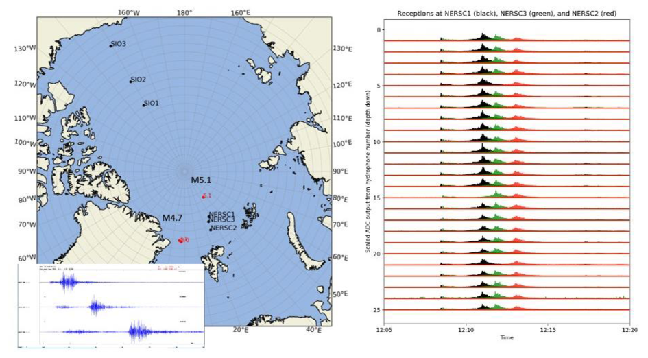
There have been some successful attempts to record earthquakes on acoustic moorings. Furthermore, hydrophone moorings have proven effective in recording ice shelf calving events and hydrophones are routinely used to detect tsunami waves in tsunami warning systems around the globe. In that regard, hydrophone arrays in the NAMO moorings represent a promising technology for filling the monitoring gap for geohazards in the Arctic region. Continuous acoustic recording from moorings in the Arctic Ocean will provide a unique and powerful dataset to study the geohazards in this region.
Methods and tools to detect signatures of earthquakes in acoustic recordings will be developed, where arrival times of seismic phases will be picked in a reliable and consistent manner. Initially, methods will be tested on existing data from acoustic experiments during CAATEX and INTAROS, as well as hydrophone data from OBS systems that were deployed during INTAROS. As data from HiAOOS moorings become available, that dataset will form the core of development and testing activities. Waveform cross correlation and template matching methods, which have shown promising results for earthquake detection and phase picking from ground motion waveform data, will be utilized and the potential for developing more sophisticated machine learning algorithms will be explored. The acoustic phase arrivals will then be combined with phase picks from land-based seismic networks, for locating the detected events. Due to the large seismological monitoring gap in the Arctic Ocean, the acoustic data is expected to significantly decrease the detection threshold and lead to much more accurate event locations.